Saturday, September 12, 2009

Hiking: Engelberg - Rugghubelhütte - Bannalp - Oberrickenbach


We took off this morning to do a hike round the Bannalp mountain behind Brunni. It was a foggy cold morning, but with an optimistic smile we checked in at the Brunni cable car at 9 AM. And we were rewarded. Just as we reached Rugghubelhütte, the sun came out of the clouds and gave us some view. And the hosts at Rugghubelhütte had just taken a plum pie out of the oven. Coffee break at mountain hut, swiss style.

Around the hut, there are tons with marmots. They are preparing for the winter, and look like overweight hares standing and looking at you. Funny little creatures. The hike continues up to the Rotgrätli pass at 2556 m, and then you walk along with beatiful views of the surrounding glaciers. We ended up at Chrüzhütte, had some bread and cheese and headed back to Engelberg with lift to Oberrickenbach, then bus to Wolfenschiessen and then train. It sounds worse than it is, the swiss public transport works great as always.

Time: 5 - 6 hours
Season: July - October

Difficulty: 3/5

Friday, July 24, 2009

Canyoning: Chli Schliere


25 minutes down the valley, lies one of the best spots in Switzerland for canyoning. And boy, it was good!

Canyoning is simply to go down a canyon by sliding, repelling, jumping and walking through the water. Amazing fun, and a good work-out too. The Chli Schliere-river is the most extreme Canyoning in the area, but there are several other easier ones as well.

The nature was spectacular, with cliff walls 100 meter + at times on the sides. And the rock even formed an arch above us at one place.

Difficulty: 5/5
Cost: 180 CHF including all equipment you need
Season: June - September
Time: 4-5 hours


Interested, we organise Canyoning, so call us at +41786753366 or send an e-mail to booking@skilodgeengelberg.com

Here is a video of Chli Schliere from an outdoor company in Interlaken :


Hiking: Engelberg - Zingel - Grafenort


Another bluebird weather day today, so we thought we'd head to Bergrestaurant Zingel, a little mountain restaurant, pitched between a 500 meter dropoff and the Zingel Peak.

You walk from the Ski Lodge to Titlisbahn, and along the artificial Lake. At Oertingen, you take a left and thereafter the signs will start pointing to Zingel. The first part through the forest was a little wet, it is almost like a rainforest on the north facing sides here. We passed a couple of streams, making their way over boulders and waterfalls. Really nice.

The hike after that is spectacular, with amazing views of the valley and massive cliffs on both sides. We arrived at the Zingel, and had a cold platter and som cold drinks. And the view, the view ladies & gentlemen!

The hike down to Grafenort was a bit muddy through the forest, and after that we took the train back. Mission complete!

Time: 5 - 6 hours with train ride (train leaves XX.50 every hour during daylight)
Difficulty: 3/5
Season: July - October

Friday, July 17, 2009

Paragliding: Engelberg from above

Yesterday our friend Kim came up to Engelberg with a tandem paragliding chute . He brought me up for two amazing flights from two different starting points on Brunni. We used his 46 m2 wing to cruise up and down the thermal winds created by the sun heating the land below us. You could stay up for almost as long as you wanted with those up-going winds. Hobby meteorologist as I am (our new weather station is hopefully up soon!) I’m really impressed by the skills of these paragliders, and how they can read the movements of the small clouds above us to find the right spots for thermal action.

The valley offers great paragliding possibilities, and has several local companies, including Flugschule Zentral , Outventure and Euroflugschule taking you up for tandem flights . Plus it’s a perfect destination for paragliding clubs schools from low land Europe (UK, Netherlands etc) to have summer camps. You can start from both the Brunni, Titlis or the Führenalp side, at various levels.


I managed to take a few pics and films below. And Kim let me steer the wing for quite a bit of the ride, but stopped my when I wanted to test a landing. Probably wise of him…


The 35km/h speed wind is causing the slightly noisy sound.


View flying over the village and our Lodge. Just above the train station in the middle it is - the small bright thing in the garden i our new sauna and hot tub deck.

View looking east into the end of the valley, towards Führenalp.

View from above Brunni, view the Flühmatt houses and village lake.


Slightly small helmet...


Happy after a smooth landing.

Friday, July 3, 2009

Hiking: Spannorthütte - amazing

Yesterday we headed for Spannorthütte, a SAC (Schweizer Alpenclub) hut with a breathtaking location. Grosse Spannort and Kleine Spannort are two of the most characteristic peaks in the Engelberg valley, they look like shark teeth stretching towards the sky. The hut itself is located right under the massive cliffs.

The walk to the top is about 4 hours, and the first hour is an easy walk in the valley. We took a dip in the river before the really steep part began. The hike is a bit technical, with ropes to hold on to when it gets too steep. At the top, we had lunch and a chat with Marianne who runs the hut. Really nice.

You can do it as a day hike, or you can have dinner and sleep under the stars at the hut and walk down the day after. It costs 66 Swiss francs, roughly 42 €, for dinner, bed and breakfast. And the view of course...

Their home page is spannorthutte.ch

Difficulty: 4/5
Time: 7 hours
Season: July - October


Extreme Hiking Picture.


Wednesday, July 1, 2009

Easy hiking: Trübsee - Engelberg


Me and Johan did an easy morning hike today in the amazing weather. We took the cable car up to Trübsee, took a stroll around the lake and wandered down the meadows and cows to Engelberg. It is a easy 2-hour walk, perfect if you only have a couple of spare hours or arrive at lunch.

The snow is almost gone up in the ski system now, so the Jochpass hikes over to Engstlensee will be avaliable soon. Oh, and by the way, today we officially opened up for the summer season. Welcome!

(green is lift, red is walking.)


Difficulty: 1/5
Time: 2 hours
Season: June - October


Approaching 30, better save the legs.


"The hills are alive, with the sound of muuuusic"


Happy guy.


Cows are big, Johan is small


The peak of Titlis.


Me in the foreground, but even nicer is our new after-hike hangout. Soon ready!

Wednesday, June 17, 2009

Via Ferrata - Führenwand

Me and Niklas took off at 4 pm to do a Via Ferrata, and as happy beginners, we went straight for the "difficult" of course. How scary can it be? Well, it was a bit scary. At least if your name is Niklas and you suffer from vertigo as soon as you click out of your skis.

But, it was a stunning climb up to Führenalp, especially the last part where you climb on a rope ladder for 30 meters. The weather today was perfect bluebird, 23 degrees - and we wouldn't recommend to do it in anything but dry weather. There are better places to slip. (No worries, Via Ferrata is perfectly safe. But slipping is never fun.)

As we were beginners, we also managed to miss the last lift down, so we had a nice jog down the mountain instead. And found a brand new downhill biking trail, which will eventually end up on this blog too.

Here are some pics:


Yes, that's the guy with vertigo to the right.


Niklas examining the ladder closely.


In this picture, he still has no clue what awaits.


"Slowwwwlllllyyyyy, sloowwwwlllllly."


The climb is about two hours to the top, and you can take a lift down after a cold beer. For the lowdown on what/where/when/why, go to Engelberg.ch's Via Ferrata Guide.

Monday, June 15, 2009

Tip: Lake Lucerne


Oskar & Jon on a pedal boat
Originally uploaded by Ski Lodge Engelberg

If you (or your feet!) feel like doing a day excursion from Engelberg, Lucerne is just a 60 minute train ride away. Grab some grilled chicken and baguette at the station, walk over the bridge and rent a pedal boat - and pedal away. The cleanest lake in Switzerland, an alpenpanorama and a picnic. Life isn't just about hiking...

VIa Ferrata - Brunni


Yesterday, we were testing the Via Ferrata-trails on the Brunni-side. Via Ferrata can be described as rock climbing for beginners, a more advanced form of hiking. Brunni has several trails, and we started out with easiest one. There are several Via Ferrata-trails in the Engelberg valley, ranging from easy to difficult. A difficult one is right next to Fuhrenalp, where we go biking - looks pretty steeeeeeeeeep.

A link to Engelberg.ch with all trails.


Friday, June 12, 2009

Mountainbiking at Führenalp


Me, Elin & Joline killed it today...or at least we made it down from Führenalp in one piece. 23 degrees, sunny and beatiful today.

(Green is where you take the lift, red is when you bike.)

Thursday, June 11, 2009

Hiking: Engelberg - Grafenort - taking the train back


Today we logged another great hike in the valley. We found a nice service called Quikmaps, so you get a better picture of where we've been.

We started at the tourist center, walking up along monastery and up through the forest to Flühmatt. I stayed at the Flühmatt farm during the winter season 2003, at Fränzi & Bixi. So I've walked this 40-minute hike more times than I can remember.

From Flühmatt, we continued all the way up to Brunnihütte, and then we turned north and had the mountain ridge on our right hand side. Loads of cows, beautiful flower fields and stunning views. We ended up in Grafenort, 500 meters below Engelberg, and took the train back to the village. After enjoying a cold one down at Gasthaus Grafenort.

Eric


"Hmm, I think its upside down"


90 minutes to Brunnihütte


Cow attack! 22 degrees, sunny and nice.


The swiss know their signs.


Aaaahhh.


Lunch with a view. And a BBQ too!


Gasthaus Grafenort.

Thursday, June 4, 2009

Hiking: Rugghübelhütte – we could see it all the way from our Lodge!


For this week’s hike, we decided to go for Rugghubelhutte, as it’s early in the season and there is still snow left on north facing slopes. During dinner Tuesday evening, we looked up on the mountains north east of us, and spotted the hütte Oskar had pointed out for us.

(look, just left of the red flag it is, you might have to zoom a bit...)

On Wednesday morning at a quarter to 10 we started from the Lodge. You could take the Brunni cable car, which would save you an hour and a bit, but we felt strong and wanted to do it the proper way. With Elin being a former cross country skier and Joline ex-road racing cyclist, I didn’t have to wait. It was more the other way around to be honest… Wet of sweat we got up to the hütte, which serves nice food and actually has 80 beds for stayovers (seems to me as very tight, as the place isn’t that big at all). After investing in beer and soda, we sat down outside and hungrily ate the salmon pasta salad Elin had prepared.

(Joline and Elin walking up the first part of Brunni)

(the viewpoint just above Rigidal- but honestly all of the hike is a long viewpoint - our goal in the upper left corner)

(Elin looking at Hahnen, the mountain on our logo)

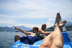
(beer and salomon pasta sallad)

There are several roads and trails to choose from to get up to the upper eastern part of the Brunni ski area. From here, just above Rigidalstafel, there is only one trail to follow, as you are walking with a massive cliffdrop below you on your right and one above you on your left hand side. This is the only way to access the fields of which the Rugghubelhutte is located on. We took the decent route down from Rigidal to the left, towards Ende der Welt, through the forest on the east side of Brunni.

(on the way down - really cool rock shapes)

(low tech internet map - black pen points at Rugghublehutte and blue at Rigidal)

We needed 3.5 hours to get up, including some photo and water breaks. We spent an hour and a half up there and walked down in 2.45h. This is a nice day project that can be done without going up too early and still coming home timely before the pre dinner sauna. No tricky parts, and no steep stuff, so people afraid of heights can still do it.

Today I’m slightly tired in my legs, and a bit red in my face as I forgot to put on sunscreen. However, feels good to have been up there. Later this summer I’m keen on continuing up to the ridge north of Rugghubelhutte, and walk down on the back side of Brunni, ening up in Bannalp and later Niederkrirchenbach. But that’s a proper full day thing, and you should wait until July as the back side of Brunni is north facing.(Niklas stopping and drinking)

(Joline looking down towards Ende der Welt and Engelberg)


(appraktly some construction work up at the hütte - and they were lifting everything here with heli!)


On the way down we found this cool little guy on the trail.

Now back to work on our houses! Cheers!

//

Niklas


http://www.oskarenander.com/